APRSWXNET Network - other tables for LA include: All Networks, METAR, RAWS, see our homepage.
|
Also try the full-featured calculator/DD model | |
|
| |||||||||||||||||||||||||
|
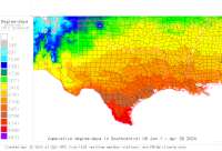
Lousiana USA Weather Data, Plant Disease Risk and Degree-Day Models APRSWXNET Network - other tables for LA include: All Networks, METAR, RAWS, see our homepage. | |||||||||||||||||||||||||
| |||||||||||||||||||||||||
| # | Location linked to hourly weather, plant disease models and forecasts using "Mypest Page" |
County |
Re- cent data QA |
Fore- cast based virt data |
Nearby station based virt data |
Station code, links to NWS recent weather |
Links to NWS fore- casts |
Net- work Elev. (ft) |
Lat./ Long. (Dec. Deg.) |
Max-min temperature data and degree-days (click radio button to calc.) |
10 yr avgs |
30 yr avgs |
nmme fcast |
cfs fcast |
||||||||||
|---|---|---|---|---|---|---|---|---|---|---|---|---|---|---|---|---|---|---|---|---|---|---|---|---|
| 1 | Abbeville DW4071 | Vermilion Pa |
|
na na |
na na |
|
|
7 | 29.87500 -92.21833 |
2021
|
2020
|
2019
|
2018
|
2017
|
2016
|
AVG | AVG | nmme | cfs | |||||
| 2 | Abita Springs DW2047 | Saint Tamman |
|
na na |
na na |
|
|
45 | 30.48111 -89.93417 |
2021
|
2020
|
2019
|
2018
|
2017
|
2016
|
AVG | AVG | nmme | cfs | |||||
| 3 | N5YHM13 ABITA SPRINGS | Saint Tamman |
|
na na |
na na |
|
|
65 | 30.47083 -90.04278 | nmme | cfs | |||||||||||||
| 4 | KF5YNN Amite | Tangipahoa P |
|
na na |
na na |
|
|
178 | 30.72556 -90.41444 |
2021
|
2020
|
2019
|
2018
|
2017
|
AVG | AVG | nmme | cfs | ||||||
| 5 | Baton Rouge W5KRO | East Baton R |
|
na na |
na na |
|
|
59 | 30.52111 -90.99222 |
2021
|
2020
|
2019
|
2018
|
2017
|
2016
|
AVG | AVG | nmme | cfs | |||||
| 6 | Belle Chasse CW3916 | Jefferson Pa |
|
na na |
na na |
|
|
3 | 29.83389 -90.00306 |
2021
|
2020
|
2019
|
2018
|
2017
|
2016
|
AVG | AVG | nmme | cfs | |||||
| 7 | Blanchard DW5467 | Caddo Parish |
|
na na |
na na |
|
|
240 | 32.60944 -93.87778 |
2021
|
2020
|
2019
|
2018
|
2017
|
2016
|
AVG | AVG | nmme | cfs | |||||
| 8 | Bossier City CW6029 | Caddo Parish |
|
na na |
na na |
|
|
173 | 32.57667 -93.72528 |
2021
|
2020
|
2019
|
2018
|
2017
|
2016
|
AVG | AVG | nmme | cfs | |||||
| 9 | Carencro W5MLE | Saint Landry |
|
na na |
na na |
|
|
46 | 30.33167 -92.05167 |
2021
|
2020
|
2019
|
2018
|
2017
|
2016
|
AVG | AVG | nmme | cfs | |||||
| 10 | Chauvin DW0358 | Lafourche Pa |
|
na na |
na na |
|
|
0 | 29.34556 -90.62944 |
2021
|
2020
|
2019
|
2018
|
2017
|
2016
|
AVG | AVG | nmme | cfs | |||||
| 11 | Covington CW6488 | Saint Tamman |
|
na na |
na na |
|
|
26 | 30.48778 -90.14028 |
2021
|
2020
|
2019
|
2018
|
2017
|
2016
|
AVG | AVG | nmme | cfs | |||||
| 12 | Kaplan CW2220 | Vermilion Pa |
|
na na |
na na |
|
|
13 | 29.98139 -92.27389 |
2021
|
2020
|
2019
|
2018
|
2017
|
2016
|
AVG | AVG | nmme | cfs | |||||
| 13 | Dry Prong DW5212 | Grant Parish |
|
na na |
na na |
|
|
165 | 31.58556 -92.60167 |
2021
|
2020
|
2019
|
2018
|
2017
|
2016
|
AVG | AVG | nmme | cfs | |||||
| 14 | Raceland DW1103 | Lafourche Pa |
|
na na |
na na |
|
|
10 | 29.69861 -90.57056 |
2021
|
2020
|
2019
|
2018
|
2017
|
AVG | AVG | nmme | cfs | ||||||
| 15 | Shreveport DW1637 | Caddo Parish |
|
na na |
na na |
|
|
194 | 32.38361 -93.72111 |
2021
|
2020
|
2019
|
2018
|
2017
|
2016
|
AVG | AVG | nmme | cfs | |||||
| 16 | Ponchatoula DW2721 | Tangipahoa P |
|
na na |
na na |
|
|
23 | 30.46000 -90.44972 |
2021
|
2020
|
2019
|
2018
|
2017
|
2016
|
AVG | AVG | nmme | ||||||
| 17 | Gretna DW6888 | Jefferson Pa |
|
na na |
na na |
|
|
0 | 29.87444 -90.03722 |
2021
|
2020
|
2019
|
2018
|
2017
|
2016
|
AVG | AVG | nmme | cfs | |||||
| 18 | Pecan Island DW7368 | Vermilion Pa |
|
na na |
na na |
|
|
3 | 29.65028 -92.41861 |
2021
|
2020
|
2019
|
2018
|
2017
|
2016
|
AVG | AVG | nmme | cfs | |||||
| 19 | Shreveport DW8306 | Caddo Parish |
|
na na |
na na |
|
|
161 | 32.41750 -93.69361 |
2021
|
2020
|
2019
|
2018
|
2017
|
2016
|
AVG | AVG | nmme | cfs | |||||
| 20 | Monticello DW9592 | West Carroll |
|
na na |
na na |
|
|
92 | 32.60944 -91.35333 |
2021
|
2020
|
2019
|
2018
|
2017
|
2016
|
AVG | AVG | nmme | cfs | |||||
| 21 | Covington EW0561 | Saint Tamman |
|
na na |
na na |
|
|
25 | 30.46750 -90.14083 |
2021
|
2020
|
2019
|
2018
|
2017
|
2016
|
AVG | AVG | nmme | cfs | |||||
| 22 | Ethel EW0793 | East Felicia |
|
na na |
na na |
|
|
226 | 30.78694 -91.09194 |
2021
|
2020
|
2019
|
2018
|
2017
|
2016
|
AVG | AVG | nmme | cfs | |||||
| 23 | Lutcher EW1043 | Saint James |
|
na na |
na na |
|
|
31 | 30.05611 -90.69917 |
2021
|
2020
|
2019
|
2018
|
2017
|
2016
|
AVG | AVG | nmme | cfs | |||||
| 24 | Metairie EW1090 | Jefferson Pa |
|
na na |
na na |
|
|
0 | 30.00472 -90.14167 |
2021
|
2020
|
2019
|
2018
|
AVG | AVG | nmme | cfs | |||||||
| 25 | Bastrop EW1438 | Morehouse Pa |
|
na na |
na na |
|
|
144 | 32.80083 -91.91972 |
2021
|
2020
|
2019
|
nmme | cfs | ||||||||||
| 26 | Baton Rouge EW1616 | Assumption P |
|
na na |
na na |
|
|
59 | 30.00000 -91.00000 |
2021
|
2020
|
2019
|
2018
|
2017
|
2016
|
AVG | AVG | nmme | cfs | |||||
| 27 | Thibodaux EW2940 | Lafourche Pa |
|
na na |
na na |
|
|
11 | 29.75694 -90.82028 |
2021
|
2020
|
2019
|
2018
|
2017
|
2016
|
AVG | AVG | nmme | cfs | |||||
| 28 | Belle Chasse EW3364 | Jefferson Pa |
|
na na |
na na |
|
|
98 | 29.85944 -89.99167 |
2021
|
2020
|
2019
|
2018
|
2017
|
2016
|
AVG | AVG | nmme | cfs | |||||
| 29 | Vacherie EW3833 | Saint John t |
|
na na |
na na |
|
|
10 | 29.93361 -90.68000 |
2021
|
2020
|
2019
|
2018
|
2017
|
2016
|
AVG | AVG | nmme | cfs | |||||
| 30 | Houma EW3858 | Lafourche Pa |
|
na na |
na na |
|
|
16 | 29.55528 -90.63861 |
2021
|
2020
|
2019
|
2018
|
2017
|
2016
|
AVG | AVG | nmme | cfs | |||||
| 31 | Gueydan EW4807 | Vermilion Pa |
|
na na |
na na |
|
|
3 | 29.89972 -92.59972 |
2021
|
nmme | cfs | ||||||||||||
| 32 | Houma EW5037 | Lafourche Pa |
|
na na |
na na |
|
|
3 | 29.53667 -90.67167 |
2021
|
2020
|
2019
|
2018
|
2017
|
2016
|
AVG | AVG | nmme | cfs | |||||
| 33 | Madisonville EW5825 | Saint Tamman |
|
na na |
na na |
|
|
34 | 30.45194 -90.21778 |
2021
|
2020
|
2019
|
2018
|
2017
|
2016
|
AVG | AVG | nmme | cfs | |||||
| 34 | Alexandria EW6201 | Rapides Pari |
|
na na |
na na |
|
|
79 | 31.27056 -92.49667 |
2021
|
2020
|
2019
|
2018
|
2017
|
2016
|
AVG | AVG | nmme | cfs | |||||
| 35 | New Orleans EW6362 | Jefferson Pa |
|
na na |
na na |
|
|
3 | 29.97306 -90.08528 |
2021
|
2020
|
2019
|
2018
|
2017
|
2016
|
AVG | AVG | nmme | cfs | |||||
| 36 | Georgetown EW6758 | Winn Parish |
|
na na |
na na |
|
|
174 | 31.79694 -92.58083 |
2021
|
2020
|
2019
|
2018
|
2017
|
2016
|
AVG | AVG | nmme | cfs | |||||
| 37 | Rayville EW6856 | Richland Par |
|
na na |
na na |
|
|
20 | 32.50000 -91.80000 |
2021
|
2020
|
2019
|
2018
|
2017
|
2016
|
AVG | AVG | nmme | cfs | |||||
| 38 | Lockport EW6903 | Lafourche Pa |
|
na na |
na na |
|
|
66 | 29.66000 -90.54472 |
2021
|
2020
|
2019
|
2018
|
2017
|
2016
|
AVG | AVG | nmme | cfs | |||||
| 39 | Shreveport EW7656 | Caddo Parish |
|
na na |
na na |
|
|
184 | 32.56667 -93.78722 |
2021
|
2020
|
2019
|
2018
|
2017
|
2016
|
AVG | AVG | nmme | cfs | |||||
| 40 | Gretna EW8473 | Jefferson Pa |
|
na na |
na na |
|
|
13 | 29.90722 -90.04861 |
2021
|
2020
|
2019
|
2018
|
2017
|
AVG | AVG | nmme | cfs | ||||||
| 41 | Toro EW8707 | Sabine Paris |
|
na na |
na na |
|
|
150 | 31.29889 -93.53889 |
2021
|
2020
|
2019
|
2018
|
2017
|
AVG | AVG | nmme | cfs | ||||||
| 42 | Metairie EW9083 | Saint Charle |
|
na na |
na na |
|
|
0 | 29.98083 -90.19861 |
2021
|
2020
|
2019
|
2018
|
2017
|
AVG | nmme | cfs | |||||||
| 43 | Covington EW9369 | Saint Tamman |
|
na na |
na na |
|
|
38 | 30.43889 -90.16000 |
2021
|
2020
|
2019
|
2018
|
2017
|
AVG | AVG | nmme | cfs | ||||||
| 44 | FW0094 Slidell | Saint Tamman |
|
na na |
na na |
|
|
9 | 30.28139 -89.77306 |
2021
|
2020
|
2019
|
2018
|
2017
|
AVG | nmme | cfs | |||||||
| 45 | FW0324 Thibodaux | Lafourche Pa |
|
na na |
na na |
|
|
19 | 29.87306 -90.81722 |
2021
|
2020
|
2019
|
nmme | cfs | ||||||||||
| 46 | FW0338 Plaucheville | Avoyelles Pa |
|
na na |
na na |
|
|
39 | 30.94361 -91.96500 |
2021
|
2020
|
2019
|
2018
|
nmme | cfs | |||||||||
| 47 | FW0350 Covington | Saint Tamman |
|
na na |
na na |
|
|
45 | 30.44444 -90.09833 |
2021
|
2020
|
2019
|
nmme | cfs | ||||||||||
| 48 | FW1110 Kenner | Saint Charle |
|
na na |
na na |
|
|
3 | 30.02833 -90.22444 |
2021
|
2020
|
2019
|
nmme | cfs | ||||||||||
| 49 | FW1193 St Gabriel | Iberville Pa |
|
na na |
na na |
|
|
16 | 30.30806 -91.10056 |
2021
|
2020
|
2019
|
2018
|
nmme | cfs | |||||||||
| 50 | FW1251 Lacombe | Saint Tamman |
|
na na |
na na |
|
|
52 | 30.32667 -89.97000 |
2021
|
2020
|
2019
|
nmme | cfs | ||||||||||
| 51 | FW1622 New Orleans | Jefferson Pa |
|
na na |
na na |
|
|
5 | 29.94306 -90.06944 |
2021
|
2020
|
2019
|
2018
|
nmme | cfs | |||||||||
| 52 | FW1704 Mandeville | Saint Tamman |
|
na na |
na na |
|
|
62 | 30.41778 -90.07278 |
2021
|
2020
|
2019
|
nmme | cfs | ||||||||||
| 53 | FW2060 Gonzales | Livingston P |
|
na na |
na na |
|
|
43 | 30.27917 -90.93056 |
2021
|
2020
|
2019
|
nmme | cfs | ||||||||||
| 54 | FW2170 Haughton | Caddo Parish |
|
na na |
na na |
|
|
230 | 32.57250 -93.60194 |
2021
|
2020
|
2019
|
nmme | cfs | ||||||||||
| 55 | FW3307 Lacombe | Saint Tamman |
|
na na |
na na |
|
|
14 | 30.31500 -89.90444 |
2021
|
2020
|
2019
|
2018
|
nmme | cfs | |||||||||
| 56 | FW3792 Baton Rouge | East Baton R |
|
na na |
na na |
|
|
43 | 30.34472 -91.04361 |
2021
|
2020
|
2019
|
nmme | cfs | ||||||||||
| 57 | FW3911 Fortuna | Vermilion Pa |
|
na na |
na na |
|
|
11 | 30.00000 -92.00000 |
2021
|
2020
|
2019
|
2018
|
nmme | cfs | |||||||||
| 58 | FW4455 Prairieville | Livingston P |
|
na na |
na na |
|
|
36 | 30.28833 -90.97306 |
2021
|
2020
|
2019
|
nmme | cfs | ||||||||||
| 59 | FW4663 Thibodaux | Lafourche Pa |
|
na na |
na na |
|
|
13 | 29.77444 -90.78556 |
2021
|
2020
|
2019
|
nmme | cfs | ||||||||||
| 60 | FW5486 Carencro | Saint Landry |
|
na na |
na na |
|
|
59 | 30.31556 -92.02194 |
2021
|
2020
|
2019
|
nmme | cfs | ||||||||||
| 61 | FW5707 Pineville | Rapides Pari |
|
na na |
na na |
|
|
111 | 31.37972 -92.46750 | nmme | cfs | |||||||||||||
| 62 | FW5779 Carencro | Saint Landry |
|
na na |
na na |
|
|
55 | 30.31944 -92.05611 |
2021
|
2020
|
2019
|
nmme | cfs | ||||||||||
| 63 | FW5866 Duson | Lafayette Pa |
|
na na |
na na |
|
|
29 | 30.16472 -92.12000 |
2021
|
2020
|
2019
|
nmme | cfs | ||||||||||
| 64 | FW5869 Baton Rouge | East Baton R |
|
na na |
na na |
|
|
59 | 30.40278 -91.16639 |
2021
|
2020
|
2019
|
nmme | cfs | ||||||||||
| 65 | FW6044 Bourg | Lafourche Pa |
|
na na |
na na |
|
|
13 | 29.55944 -90.60111 |
2021
|
2020
|
2019
|
nmme | cfs | ||||||||||
| 66 | FW6181 Mandeville | Saint Tamman |
|
na na |
na na |
|
|
52 | 30.38778 -90.06611 |
2021
|
nmme | cfs | ||||||||||||
| 67 | FW6607 New Orleans | Jefferson Pa |
|
na na |
na na |
|
|
16 | 29.96111 -90.03306 |
2021
|
nmme | cfs | ||||||||||||
| 68 | FW7671 Mt Airy | Saint John t |
|
na na |
na na |
|
|
19 | 30.05361 -90.64222 |
2021
|
nmme | cfs | ||||||||||||
| 69 | FW7862 Mandeville | Saint Tamman |
|
na na |
na na |
|
|
45 | 30.37917 -90.02139 |
2021
|
nmme | cfs | ||||||||||||
| 70 | FW7886 Prairieville | Livingston P |
|
na na |
na na |
|
|
26 | 30.29306 -90.96667 |
2021
|
nmme | cfs | ||||||||||||
| 71 | FW7908 Elmer | Rapides Pari |
|
na na |
na na |
|
|
213 | 31.12167 -92.68194 |
2021
|
nmme | cfs | ||||||||||||
| 72 | FW8402 Youngsville | Lafayette Pa |
|
na na |
na na |
|
|
36 | 30.11361 -92.01056 |
2021
|
nmme | cfs | ||||||||||||
| 73 | FW8433 Oak Grove | West Carroll |
|
na na |
na na |
|
|
114 | 32.86250 -91.35778 |
2021
|
nmme | cfs | ||||||||||||
| 74 | FW8544 Thibodaux | Assumption P |
|
na na |
na na |
|
|
16 | 29.84972 -90.90194 | nmme | cfs | |||||||||||||
| 75 | FW8890 Bienville | Bienville Pa |
|
na na |
na na |
|
|
206 | 32.25250 -92.98778 |
2021
|
nmme | cfs | ||||||||||||
| 76 | FW8899 Minden | Webster Pari |
|
na na |
na na |
|
|
318 | 32.63444 -93.25472 |
2021
|
nmme | cfs | ||||||||||||
| 77 | FW9742 Paulina | Saint James |
|
na na |
na na |
|
|
19 | 30.03778 -90.74139 |
2021
|
nmme | cfs | ||||||||||||
| 78 | FW9932 Lake Arthur | Jefferson Da |
|
na na |
na na |
|
|
9 | 30.06278 -92.71028 |
2021
|
nmme | cfs | ||||||||||||
| 79 | Gramercy CW7580 | Ascension Pa |
|
na na |
na na |
|
|
13 | 30.06333 -90.69861 |
2021
|
2020
|
2019
|
2018
|
2017
|
2016
|
AVG | AVG | nmme | cfs | |||||
| 80 | GW0043 Slidell | Saint Tamman |
|
na na |
na na |
|
|
13 | 30.23083 -89.78972 | nmme | ||||||||||||||
| 81 | GW0093 Mandeville | Saint Tamman |
|
na na |
na na |
|
|
16 | 30.34944 -90.06028 | nmme | ||||||||||||||
| 82 | GW0582 Slidel | Saint Tamman |
|
na na |
na na |
|
|
45 | 30.31972 -89.77139 |
2021
|
nmme | cfs | ||||||||||||
| 83 | GW0610 Metairie | Jefferson Pa |
|
na na |
na na |
|
|
16 | 29.98444 -90.13861 |
2021
|
nmme | cfs | ||||||||||||
| 84 | GW1367 DENHAM SPRINGS | East Baton R |
|
na na |
na na |
|
|
78 | 30.55917 -90.95222 | nmme | cfs | |||||||||||||
| 85 | GW1868 VACHERIE | Saint James |
|
na na |
na na |
|
|
13 | 29.93694 -90.69306 | nmme | cfs | |||||||||||||
| 86 | GW2074 CONVENT | Ascension Pa |
|
na na |
na na |
|
|
29 | 30.06944 -90.86861 | nmme | cfs | |||||||||||||
| 87 | GW2274 NEW ORLEANS | Jefferson Pa |
|
na na |
na na |
|
|
9 | 29.96028 -90.10500 | nmme | cfs | |||||||||||||
| 88 | GW3171 Lake Charles | Calcasieu Pa |
|
na na |
na na |
|
|
22 | 30.14278 -93.25389 | nmme | cfs | |||||||||||||
| 89 | GW4123 OPELOUSAS | Saint Landry |
|
na na |
na na |
|
|
68 | 30.48972 -92.09167 | nmme | cfs | |||||||||||||
| 90 | GW4801 METAIRIE | Saint Charle |
|
na na |
na na |
|
|
6 | 29.98306 -90.21667 | nmme | ||||||||||||||
| 91 | GW5218 SLIDELL | Saint Tamman |
|
na na |
na na |
|
|
42 | 30.27472 -89.75917 | nmme | ||||||||||||||
| 92 | GW5294 BATON ROUGE | East Baton R |
|
na na |
na na |
|
|
32 | 30.36556 -91.04028 | nmme | ||||||||||||||
| 93 | GW5379 GONZALES | Livingston P |
|
na na |
na na |
|
|
22 | 30.23222 -90.93111 | nmme | ||||||||||||||
| 94 | GW5674 MONTEREY | Catahoula Pa |
|
na na |
na na |
|
|
59 | 31.31278 -91.83444 | nmme | ||||||||||||||
| 95 | Lafayette CW1478 | Acadia Paris |
|
na na |
na na |
|
|
26 | 30.26500 -92.26278 |
2021
|
2020
|
2019
|
2018
|
2017
|
2016
|
AVG | AVG | nmme | cfs | |||||
| 96 | Lake Charles DW3319 | Calcasieu Pa |
|
na na |
na na |
|
|
23 | 30.35500 -93.27444 |
2021
|
2020
|
2019
|
2018
|
2017
|
2016
|
AVG | AVG | nmme | cfs | |||||
| 97 | Lake Charles DW6036 | Calcasieu Pa |
|
na na |
na na |
|
|
12 | 30.15306 -93.22694 |
2021
|
2020
|
2019
|
2018
|
2017
|
2016
|
AVG | AVG | nmme | cfs | |||||
| 98 | KA5ZCI Laplace | Saint John t |
|
na na |
na na |
|
|
7 | 30.06000 -90.44806 |
2021
|
2020
|
2019
|
2018
|
2017
|
2016
|
AVG | AVG | nmme | cfs | |||||
| 99 | Luling DW2028 | Saint John t |
|
na na |
na na |
|
|
10 | 29.89861 -90.34194 |
2021
|
2020
|
2019
|
2018
|
2017
|
2016
|
AVG | AVG | nmme | cfs | |||||
| 100 | Lutcher KE5JZM1 | Livingston P |
|
na na |
na na |
|
|
23 | 30.29556 -90.89444 |
2021
|
2020
|
2019
|
2018
|
2017
|
2016
|
AVG | AVG | nmme | cfs | |||||
| 101 | Madisonville DW3111 | Saint Tamman |
|
na na |
na na |
|
|
0 | 30.39000 -90.20583 |
2021
|
2020
|
2019
|
2018
|
2017
|
2016
|
AVG | AVG | nmme | cfs | |||||
| 102 | Monroe KD5MWL2 | Morehouse Pa |
|
na na |
na na |
|
|
80 | 32.54444 -92.00417 |
2021
|
2020
|
2019
|
2018
|
2017
|
2016
|
AVG | AVG | nmme | cfs | |||||
| 103 | New Orleans CW2378 | Saint Charle |
|
na na |
na na |
|
|
7 | 29.96889 -90.21778 |
2021
|
2020
|
2019
|
2018
|
2017
|
2016
|
AVG | AVG | nmme | cfs | |||||
| 104 | New Orleans CW4185 | Saint Charle |
|
na na |
na na |
|
|
10 | 29.95028 -90.19861 |
2021
|
2020
|
2019
|
2018
|
2017
|
2016
|
AVG | AVG | nmme | cfs | |||||
| 105 | New Orleans DW5349 | Jefferson Pa |
|
na na |
na na |
|
|
16 | 30.00389 -90.04778 |
2021
|
2020
|
2019
|
2018
|
2017
|
2016
|
AVG | AVG | nmme | cfs | |||||
| 106 | KG5WBN New Orleans | Jefferson Pa |
|
na na |
na na |
|
|
13 | 29.95389 -90.12611 | nmme | cfs | |||||||||||||
| 107 | KT0JA NEW ORLEANS | Jefferson Pa |
|
na na |
na na |
|
|
13 | 29.96889 -90.04389 | nmme | cfs | |||||||||||||
| 108 | KT5JA New Orleans | Jefferson Pa |
|
na na |
na na |
|
|
9 | 29.97972 -90.06917 |
2021
|
2020
|
2019
|
nmme | cfs | ||||||||||
| 109 | KG5FQT Paulina | Saint James |
|
na na |
na na |
|
|
6 | 30.03944 -90.71417 |
2021
|
2020
|
2019
|
2018
|
2017
|
2016
|
AVG | AVG | nmme | cfs | |||||
| 110 | AA5UY Pearl River | Saint Tamman |
|
na na |
na na |
|
|
36 | 30.42361 -89.80167 |
2021
|
2020
|
2019
|
2018
|
2017
|
2016
|
AVG | AVG | nmme | cfs | |||||
| 111 | Plain Dealing CW4290 | Caddo Parish |
|
na na |
na na |
|
|
299 | 32.90972 -93.69861 |
2021
|
2020
|
2019
|
nmme | cfs | ||||||||||
| 112 | Ponchatoula KE5JJC | Tangipahoa P |
|
na na |
na na |
|
|
246 | 30.44750 -90.35944 |
2021
|
2020
|
2019
|
2018
|
2017
|
2016
|
AVG | AVG | nmme | cfs | |||||
| 113 | K5HDE13 Port Allen | East Baton R |
|
na na |
na na |
|
|
29 | 30.41611 -91.23306 |
2021
|
nmme | cfs | ||||||||||||
| 114 | Slidell DW0550 | Saint Tamman |
|
na na |
na na |
|
|
20 | 30.29639 -89.83750 |
2021
|
2020
|
2019
|
2018
|
2017
|
2016
|
AVG | AVG | nmme | cfs | |||||
| 115 | N0KWA TALISHEEK | Saint Tamman |
|
na na |
na na |
|
|
82 | 30.53194 -89.87389 | nmme | cfs | |||||||||||||
| 116 | KC5DP Tickfaw | Tangipahoa P |
|
na na |
na na |
|
|
78 | 30.58500 -90.49806 | nmme | ||||||||||||||
| 117 | W4JI Zachary | East Baton R |
|
na na |
na na |
|
|
76 | 30.60000 -91.05000 |
2021
|
2020
|
2019
|
2018
|
2017
|
2016
|
AVG | AVG | nmme | cfs | |||||
| 118 | W5IC E Baton Rouge Par | East Baton R |
|
na na |
na na |
|
|
59 | 30.40389 -91.08444 |
2021
|
2020
|
2019
|
nmme | cfs | ||||||||||
| 119 | W5RHR Albany | Livingston P |
|
na na |
na na |
|
|
32 | 30.48639 -90.57972 |
2021
|
2020
|
2019
|
2018
|
2017
|
AVG | AVG | nmme | cfs | ||||||
| 120 | West Monroe WC5M | Ouachita Par |
|
na na |
na na |
|
|
141 | 32.52083 -92.23972 |
2021
|
2020
|
2019
|
2018
|
2017
|
2016
|
AVG | AVG | nmme | cfs | |||||
| 121 | WI5ARD Bush | Saint Tamman |
|
na na |
na na |
|
|
154 | 30.60056 -89.96917 | nmme | cfs | |||||||||||||
[USPEST.ORG/WEA Home]
[Intro]
[US DD Mapmaker]
[Main Table Index]
[Links]


|